The
1960 Valdivia earthquake or
Great Chilean Earthquake (
Spanish:
Terremoto de Valdivia/Gran terremoto de Chile) of Sunday, 22 May 1960 was the
most powerful earthquake ever recorded, rating 9.5 on the
moment magnitude scale. It occurred in the afternoon (19:11
GMT, 15:11 local time), and the resulting
tsunami affected southern Chile, Hawaii, Japan, the Philippines, eastern New Zealand, southeast Australia, and the Aleutian Islands.
The
epicenter was near
Lumaco approximately 570 kilometres (350 mi) south of
Santiago, with
Valdivia being the most affected city. The tremor caused localised tsunamis that severely battered the Chilean coast, with waves up to 25 metres (82 ft). The main tsunami raced across the Pacific Ocean and devastated
Hilo, Hawaii. Waves as high as 10.7 metres (35 ft) were recorded 10,000 kilometres (6,200 mi) from the epicenter, and as far away as Japan and the Philippines.
The death toll and monetary losses arising from such a widespread disaster are not certain. Various estimates of the total number of fatalities from the earthquake and tsunamis have been published, with the
United States Geological Survey citing studies with figures of 2,231, 3,000, or 5,700 killed and another source uses an estimate of 6,000 dead. Different sources have estimated the monetary cost ranged from
US$400 million to 800 million (or 2.9 to 5.8 billion in 2011 dollars, adjusted for inflation).
Earthquake development

Global seismic release from 1906 to 2005, the graph shows that almost 25% of the world earthquake energy in a century was concentrated in the Great Chilean Earthquake alone.

A
Valdivia street after the earthquake of 22 May 1960
The 1960 Chilean earthquake swarm was a series of strong earthquakes that affected Chile between 21 May and 6 June 1960. The first was the Concepción earthquake, and the strongest was the Valdivia earthquake.
Valdivia earthquake
The Valdivia earthquake occurred at 15:11 UTC-4 on 22 May, and affected all of Chile between
Talca and
Chiloé Island, more than 400,000 square kilometres (150,000 sq mi). Coastal villages, such as
Toltén, disappeared. At
Corral, the main port of Valdivia, the water level rose 4 m (13 ft) before it began to recede. At 16:20 UTC-4, a wave of 8 m (26 ft) struck the Chilean coast, mainly between Concepción and Chiloé. Another wave measuring 10 m (33 ft) was reported ten minutes later.
Hundreds of people were already reported dead by the time the tsunami struck. One ship,
Canelos, starting at the mouth of
Valdivia River, sank after being moved 1.5 km (0.93 mi) backward and forward in the river; its mast is still visible from the road to
Niebla.
A number of Spanish-colonial
fortifications were completely destroyed. Soil
subsidence also destroyed buildings, deepened local rivers, and created wetlands in places like the
Río Cruces and Chorocomayo, a new aquatic park north of the city. Extensive areas of the city were flooded. The electricity and water systems of Valdivia were totally destroyed. Witnesses reported underground water flowing up through the soil. Despite the heavy rains of 21 May, the city was without a water supply. The river turned brown with sediment from landslides and was full of floating debris, including entire houses. The lack of
potable water became a serious problem in one of Chile's rainiest regions.
The earthquake did not strike all the territory with the same strength; measured with the
Mercalli scale, tectonically depressed areas suffered heavier damage. The two most affected areas were Valdivia and
Puerto Octay, near the northwest corner of
Llanquihue Lake. Puerto Octay was the center of a north-south elliptical area in the
Central Valley, where the intensity was at the highest outside the Valdivia Basin. East of Puerto Octay, in a hotel in
Todos los Santos Lake, piles of plates were reported to have remained in place.
Two days after the earthquake
Cordón Caulle, a
volcanic vent close to
Puyehue volcano, erupted. Other volcanoes may also have erupted, but none was recorded due to the lack of communication in Chile at the time. The relatively low death toll in Chile (estimated at 6,000) is explained in part by the low population density in the region, and by building practices that took into account the area's high geological activity.
Natural disasters triggered
Landslides
The earthquake triggered numerous
landslides, mainly in the steep glacial valleys of the southern
Andes. Within the Andes, most landslides occurred on forested mountain slopes around the
Liquiñe-Ofqui Fault. Some of these areas remain sparsely vegetated while others have naturally developed more or less pure stands of
Nothofagus dombeyi. These landslides did not cause many fatalities nor significant economical losses because most of the areas were uninhabited, with only minor roads.
Tsunami

Map showing the travel time of the tsunami across the
Pacific and beyond. Contours are at one hour intervals.
Earthquake-induced
tsunamis affected southern Chile, Hawaii, Japan, the Philippines, Hong Kong, eastern New Zealand, southeast Australia and the
Aleutian Islands. Some localised tsunamis severely battered the Chilean coast, with waves up to 25 m (82 ft). The main tsunami crossed the Pacific Ocean at a speed of several hundred km/h and devastated
Hilo, Hawaii, killing 61 people.Hilo's position in the bay caused a cumulative bounce of tsunami waves far more destructive to Hilo than to other more exposed areas of Hawaii. In Japan, the tsunami arrived about 22 hours after the earthquake and killed 142 people. Tsunami waves as high as 10.7 m (35 ft) were recorded 10,000 km (6,200 mi) from the epicentre, several as far away as Japan and the Philippines.
At the coastal town of
Queule a
carabinero reported hundreds of people to be dead or missing some days after the tsunami. Historians Yoselin Jaramillo and Ismael Basso report that people in Queule decades later know about 50 people to have died because of the earthquake and tsunami.On 22 May, a tsunami occurred also in
Nahuel Huapi Lake, on the Argentinean side of the
Andes, more than 200 km away from Valdivia. The wave, most likely produced by an earthquake-triggered sediment slide at the lake bottom, killed two people and destroyed a pier in
San Carlos de Barilochecity.
Riñihuazo flood
During the Great Chilean Earthquake, several
landslides west of
Tralcán Mountain blocked the outflow of
Rinihue Lake. Riñihue Lake is the lowest of the
Seven Lakes chain and receives a constant inflow from the
Enco River.The blocked
San Pedro River, which drains the lake, passes through several towns before reaching the city of
Valdivia near the coast.Because the San Pedro River was blocked, the water level of Riñihue Lake started to rise quickly. Each meter the water level rose was equivalent to 20 million cubic meters, which meant that 4,800 million cubic meters of water would release into the San Pedro River (easily overpowering its flow capacity of 400 cubic metres (14,000 cu ft) per second if it rose above the final, 24-meter-high dam. This potential disaster would have violently flooded all the settlements along the course of the river in less than five hours, with more dire consequences if the dam suddenly broke.
About 100,000 people lived in the affected zone. Plans were made to evacuate Valdivia, and many people left. To avoid the destruction of the city, several military units and hundreds of workers from
ENDESA,
CORFO, and
MOP started an effort to control the lake.Twenty-seven
bulldozers were put into service, but they had severe difficulties moving in the mud near the dams, so
dykes had to be constructed with shovels from June onwards.The work was not restricted to the lake; drainages from other parts of the Seven Lakes were dammed to minimize additional flow into Riñihue Lake. These dams were removed later, with the exception of
Calafquén Lake, which still retains its dam.
By 23 June, the main dam had been lowered from 24 to 15 m (79 to 49 ft), allowing 3,000 million cubic meters of water to leave the lake gradually, but still with considerable destructive power. The team was led by ENDESA engineer
Raúl Sáez.
Cordón Caulle eruption
On 24 May, 38 hours after the main shock of the 1960 Valdivia earthquake, Cordón Caulle began a
rhyodacitic fissure eruption. Being located between two sparsely populated and isolated Andean valleys, the eruption had few eyewitnesses and received little attention by local media, which was preoccupied with the severe and widespread damage and losses caused by the earthquake. The eruption fed a 5.5 km long and N135° trending fissure where 21 individual vents have been found. These vents produced an output of about 0.25 km
3 DRE both in form of
lava flows and
tephra. The eruption ended on 22 July.
Consequences and response
Impacts in Valdivia
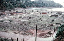
The destroyed center of Corral in Autum 1960
It has been estimated that about 40% of the houses in Valdivia were destroyed, leaving 20,000 people homeless. The most affected structures were those built of concrete, which in some cases collapsed completely due to lack of earthquake engineering. Traditional wooden houses fared better; although in many places, they were uninhabitable, they did not collapse. Houses built upon
tectonically elevated areas suffered considerably less damage compared to those on the lowlands, which absorbed great amounts of energy. Many
city blocks with destroyed buildings in the city center remained empty until the 1990s and 2000s, with some of them still used as
parking lots. Before the earthquake, some of these blocks had modern concrete buildings built after the Great Valdivia fire of 1909.
In terms of urban development, Valdivia suffered the loss of the minor but significant Cau-Cau bridge, a bridge that has not been rebuilt. The other bridges suffered only minor damage. Land subsidence in
Corral Bay improved navigability as
shoal banks, produced earlier by sediments from
Madre de Dios and other nearby gold mines, sank and were compacted. As the earthquake destroyed Valdivia's flood barriers, general land subsidence exposed new areas to flooding.
The United States quickly set up a
field hospital following the earthquake. Aided by the United States, a geological survey of Valdivia was done following the earthquake and resulted in the city's first geological map.
Mexico built and donated the public school
Escuela México after the earthquake.
The earthquakes damaged an area that had suffered a long period of economic decline, which began with shifts in trade routes, due to the expansion of
railroads in southern Chile and the opening of the
Panama Canal in 1911.
Impact in the countryside

A destroyed steel factory near
Corral - Photo from autumn 1960
The
tsunami that struck the coast of southern Chile destroyed seaside farms, killing numerous livestock and people.Barns and industrial structures were destroyed by the quake.The dairy industry was among the few industries of the affected zone that received subsidies and investment after the earthquake. It received state support through a long-term policy after the earthquake.
As a result of the earthquake, an international technological cooperation programme was established in the dairy sector. More specifically, the German and Danish governments helped to create the
Centro Tecnológico de la Leche (the Milk Technological Centre) in the
Southern University of Chile.The scholar Erik Dahmén believes that the earthquake resulted in a "
creative destruction" for farmers of Southern Chile.
The economy of the coastal town of
Queule had during the 1950s developed significantly. Its economy based on fishing, agriculture and industry had grown. Quele was connected by road in 1957 to the rest of the country and the town had developed into a
balneario. This era of prosperity ended with the 1960 earthquake.
Creation of emergency committee
After the 1960 Valdivia earthquake, a committee was formed to solve problems caused by the earthquake. It continued to operate, to develop approaches for national emergencies. In 1974 it was named
ONEMI (Spanish acronym for National Emergency and Information Office) when it was authorized by law as an independent governmental office.
Human sacrific
In the coastal village Collileufu, native Lafkenches carried out a ritual human sacrifice during the days following the main earthquake. Collileufu, located in the Budi Lake area, south of Puerto Saavedra, was in 1960 highly isolated. The Mapuche spoke primarily Mapudungun. The community had gathered in Cerro La Mesa, while the lowlands were struck by successive tsunamis. Juana Namuncura Añen, a local machi, demanded the sacrifice of the grandson of Juan Painecur, a neighbor, in order to calm the earth and the ocean.The victim was 5-year-old José Luis Painecur, an "orphan" (huacho) whose mother had gone to work as domestic worker in Santiago and left her son in charge of her father.
The sacrifice was learned about by authorities after a boy in the commune of
Nueva Imperial denounced to local leaders the theft of two horses; these were allegedly eaten during the sacrifice ritual.Two men were charged with the crime of murder and confessed, but later recanted. They were released from jail after 2 years. A judge ruled that those involved had "acted without free will, driven by an irresistible natural force of ancestral tradition." The story was mentioned in a
Time magazine article, although with little detail.
http://en.wikipedia.org/wiki/1960_Valdivia_earthquake


